A digital map has little operational value if a system cannot reliably determine where its observations were made. Navigation faces the same fundamental issue: route planning and movement control depend on knowing a platform’s position relative to its surroundings and intended path.
Geographical positioning provides that spatial reference, connecting physical locations with digital maps, sensor observations, and navigation instructions. For professional applications, its importance lies not simply in identifying a point on Earth, but in delivering location information that other systems can continuously use.
A Map Cannot Be Trusted Without Spatial Reference
Mapping is essentially a process of associating observed features with known locations. A vehicle collecting road information, a drone surveying an area, or a machine operating across a site may gather data from cameras, inertial sensors, LiDAR, and satellite systems. Positioning solutions give these observations a geographic context so they can be placed and interpreted correctly.
Without a stable reference, small location errors can become significant when datasets are combined or used for subsequent operations. A mapped object may appear displaced, separate observations may fail to align, and route-related information may be associated with the wrong part of an environment.
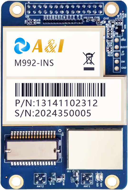
Archimedes Innovation develops positioning and perception technologies intended for intelligent systems, including applications such as aerial mapping and inspection. Its M992-INS combines GNSS and INS functions and provides position and orientation information for platforms including drones and other autonomous systems.
The significance extends beyond producing a visually accurate map. In many professional workflows, mapping data becomes an input for inspection, surveying, automation, planning, or machine control. Location quality therefore influences what can be done with the finished dataset.
Navigation Turns Position Into Movement Decisions
Navigation requires a more dynamic interpretation of location. A system needs to understand not only where a platform is, but also how it is oriented and moving in relation to a planned route. Position, heading, velocity, and timing can collectively determine whether a vehicle is following its intended trajectory.
That distinction explains why geographical positioning is particularly important for autonomous platforms. A navigation controller continuously compares current information with the desired path. If the location estimate shifts unexpectedly, the resulting correction can affect steering, braking, path planning, or other control decisions.
Dual-antenna positioning can add directional information to the location estimate. The M992-INS, for example, specifies dual-antenna GNSS observation and position-and-heading outputs, while its inertial system can provide higher-frequency measurements for navigation fusion.
Time synchronization also matters where several sensors must work together. The M992-INS supports PPS, NTP, and PTP synchronization, allowing positioning data to be coordinated with other components in an integrated system.
The Real Test Comes When Signals Become Unreliable
Open-sky conditions do not represent every mapping or navigation environment. Urban canyons, dense vegetation, tunnels, overpasses, ports, and industrial sites can complicate satellite reception. A system designed only around ideal positioning conditions may therefore struggle when its primary signals become obstructed or degraded.
Integrated GNSS/INS architectures provide another layer of resilience by combining satellite-based measurements with inertial data. Rather than treating positioning as a single measurement source, the system can use multiple inputs to maintain navigation information as operating conditions change.
The A&I PBOX is designed around this principle. Its positioning engine combines PVT, RTK, loose-coupling, and tight-coupling navigation approaches, with GNSS and IMU anomaly detection intended to support operation in environments such as dense foliage and urban canyons.
Such capabilities are relevant when continuity matters as much as nominal accuracy. A navigation platform moving through a changing environment cannot simply stop whenever satellite reception becomes less favorable. Maintaining usable position and attitude information can be essential to keeping downstream systems functioning.
System Architecture Determines How Useful Positioning Becomes
Choosing a positioning system should therefore start with the application’s operating conditions. Surveying, aerial mapping, autonomous driving, marine robotics, and industrial machinery may require different combinations of accuracy, heading information, update frequency, communications, synchronization, and environmental robustness.
Positioning solutions also need to fit the rest of the hardware and software architecture. Interfaces such as Ethernet, CAN, RS232, or RS422 can determine how readily navigation information reaches controllers and other sensors. The POSEIDON, for example, provides several of these host‑system interfaces and supports PPS, GPTP, and NTP time synchronization when paired with compatible RTK‑INS positioning modules.
A comprehensive portfolio covering positioning sensors, attitude sensors, GNSS receivers, perception sensors, and AI computing platforms is available from Archimedes Innovation. This exemplifies a crucial system-level principle: seamless integration of location data with perception, calculation, and control components increases the data’s value.
Rather than fixating on a single precision number, engineering teams should ensure that specifications take the full workflow into account. The right design is the one that reliably supplies the necessary geographical data in the real-world setting.
Reliable Location Data Becomes an Operational Input
Mapping and navigation ultimately depend on the same foundation: converting physical movement and observations into dependable spatial information. Mapping needs positioning to place collected features correctly, while navigation uses it to understand current movement in relation to a route or operating objective.
The positioning portfolio of Archimedes Innovation shows how this base can combine sensor data with location, attitude, time, and fundamental coordinates.
The answer to why geographical positioning is important is therefore straightforward but broader than simple location tracking. It establishes the reference that allows digital maps to represent the physical world and enables navigation systems to make informed movement decisions. Where accuracy, continuity, orientation, and integration are required, positioning becomes a core system function rather than a peripheral feature.
